Miles 21-26.2: Mission District—Fast and Flat to the Finish Line | Course Landmarks and Their History
If you think of a marathon as two 10-mile runs followed by a 10-kilometer run, then the first two segments are done and there’s only one left. A glance at the elevation map for the final 10K reveals that the biggest and steepest uphills are behind you. The Haight neighborhood, Mission District, and the Dogpatch await your arrival. Take a deep breath; you’re slowly nearing the finish line.
Written by San Francisco Marathon Ambassador Scott Benbow
Edited by Pavlína Marek
You are confronting a steep and difficult downhill from Haight Street to a relatively flat portion beginning at Market Street. I’ve never really figured out how to tackle this steep downhill so late in the race. Instead, for a couple of years, I asked my family to meet me at the top of the steepest block and I walked down that part of the course with them. It’s a great break if you need one at mile 21. If you’re a better downhill runner than I am, you may be able to put a bit of time on the clock at this point.
At the bottom of the steepest part of this downhill, you’ll be crossing Market Street. When you do, be sure to look to your left. If it’s not too foggy, you will see the Ferry Building, where you started the race and, in a few short miles, will be finishing the Marathon. To your right is the Castro District, the epicenter of San Francisco’s thriving LGBTQ+ community. In front of you is the Mission District, where you’ll be running on predominantly flat terrain for the next few miles.
Missions were promoted as places where Indigenous Peoples could find refuge and protection while being converted to Christianity. Instead, a cultural genocide took place as “crowded, harsh living conditions at the missions contributed to the Indians’ health problems, and infant mortality and death rates among young children soared. It was the tribes of the coast, the ‘Mission Indians,’ who were most drastically affected. (Library of Congress)”
In modern times, the Mission District has been home to a large Latinx population, but gentrification has caused tensions to rise in the neighborhood, especially during the past thirty years of booms and busts in the tech industry (so-called “dot-coms” around the turn of the century, Twitter, AirBnB, Salesforce in the following several years, and most recently burgeoning AI companies).
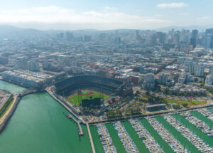
Critics claim that San Francisco is doomed in 2024, but, just as the City has done many times in the past, it is picking itself up again with massive investments in biotech and other forms of medical research. You’re in a very new neighborhood designed to attract these companies as you make your way by the Chase Center, home to the Golden State Warriors, Oracle Park, home to the San Francisco Giants, and back to the Embarcadero.

The crowds will be louder and more dense as you run the flat, wide, and fast sidewalk along the Embarcadero, under the Bay Bridge, and on to the finish line. You’ll be running over a landfill that includes some more ships like the ones you were running over in mile 1, bringing you right back to the Ferry Building, where it all began before sunrise on the day of the race.
Best of luck to all of you running the Ultramarathon, the Marathon, Half Marathons, the Alexi Pappas 10K, 5Ks, and to all spectators on race day!


